and Chasing
[Index][Archives]
The Cut-off Low September 1st 2001 - What a start to Spring: confirmed LP Supercell
report compiled by Jimmy Deguara
| Storm News and Chasing [Index][Archives] |
The Cut-off Low September 1st 2001 - What a start to Spring: confirmed LP Supercell report compiled by Jimmy Deguara |
Ben Whiteside was in position to photograph this impressive LP supercell structure!!!
I studied the models intensely using the avnPlotter days prior after being alerted by others that there was a possible good system to develop for this particular weekend. It was looking likely that the lower Hunter to the western Hunter would fire. The moisture profile was excellent especially in the Hunter but mid level moisture was expected to contaminate the atmosphere further south. The windshear was also ideal with backing expected mainly near the coast with a convergence line aligned through the Hunter to the Central Tablelands. An upper level thermal trough was expected to be situated over the region during the afternoon destabilising the atmosphere.
Determining the target area was as usual quite difficult: considering the poor road network. Anything from the Central Coast to the lower Hunter to the northern parts of the Central Tablelands were all likely targets. The best target area was surrounded by National Parks and no roads - Wollemi National Park and the Mt Yengo National Park either side of the Putty Road.
Geoff and I decided to head via the Putty Road into the lower Hunter at Bulga within easy reach of the Putty Road if need be. It was within an hour or so of any part of the Hunter and with a road option east as well. We passed through some light rain and some low topped thundery showers towards the end of the Putty Road. However, this band was rapidly heading east.
A called Matt Smith so that he could join in and he eventually met us north of Bulga. Cumulus clouds were growing and shearing quite nicely. It was warm in the low 20's. We could see some nice crisp cumulus congestus trying to break the cap mainly over the ranges but nothing broke this strong cap.
We all decided that we should head further west to get some better views of the congesting cumulus perhaps heading over to the Denman area. But as we headed towards Jerrys Plains, I quickly noted a lookout option near the roadside on top of an elevated hill. After all, the congestus could be observed from here. So we U-turned and parked there.
This gradually headed southeast with the dominant northwesterly wind field. We still had a shallow northeast wind where we were. During updates, I found that dewpoints were better in Sydney but still good along the Central Coast perhaps less near Newcastle. Scone to our north was in single figures indicating comparitively drier air. Cumulus fields in that area had cleared.
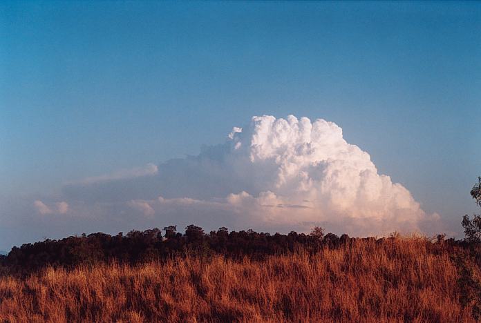
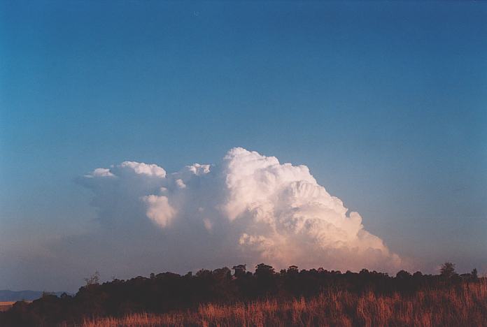
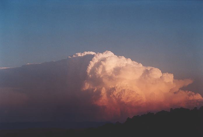
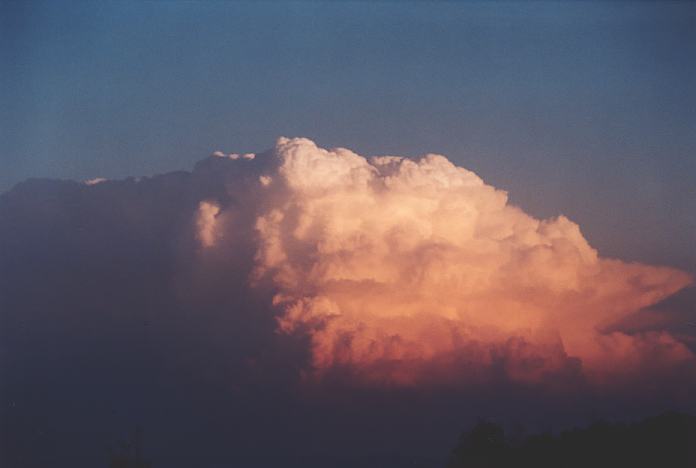
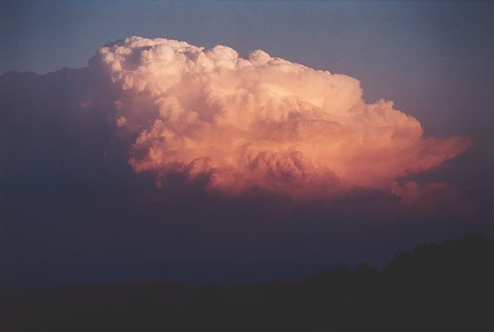
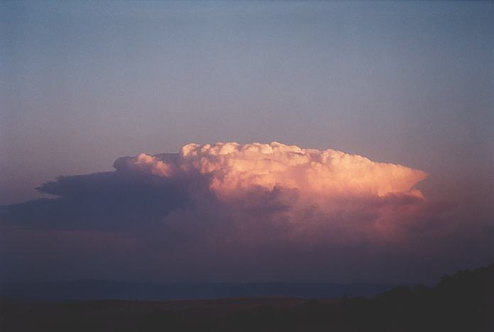
But I had forgotten one important detail: the lower level windshear would cause it to back build slowing the overall storm movement. Well, isn't this what we were observing. By the time I noticed this, it was perhaps too late to move. So we remained in our position content with a sunlit structure.
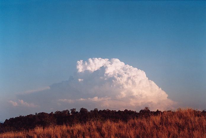
Then calls came through to Matt and myself that the storm showed red on radar - hail. "Finally!!!", I thought almost in a sigh of relief. At one stage talking to Paul I thought I had lost my touch in recognising severe storm structures!!! A warning was also put out by the Bureau of large hail, damaging winds and very heavy rainfall. The phone calls and comments made by those at the other end certainly added to the excitement of this unique event.
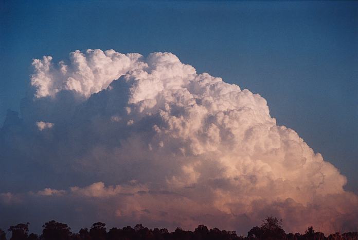
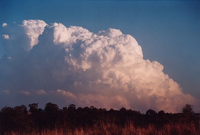
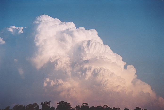
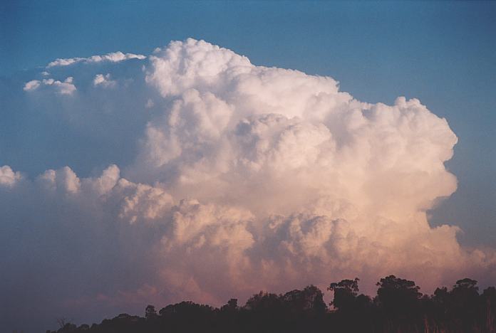
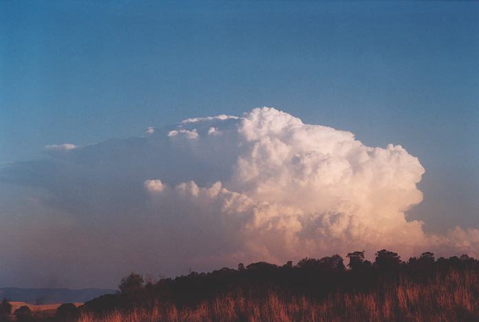
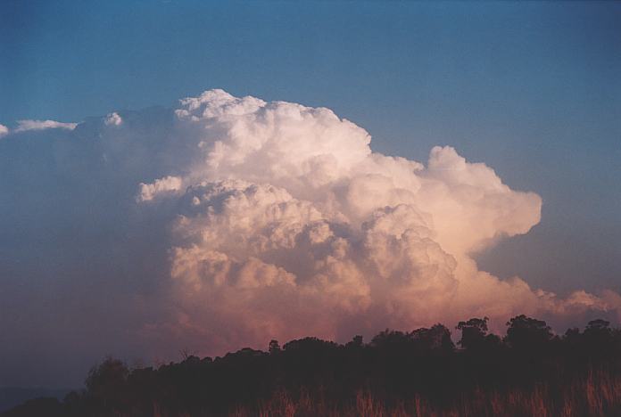
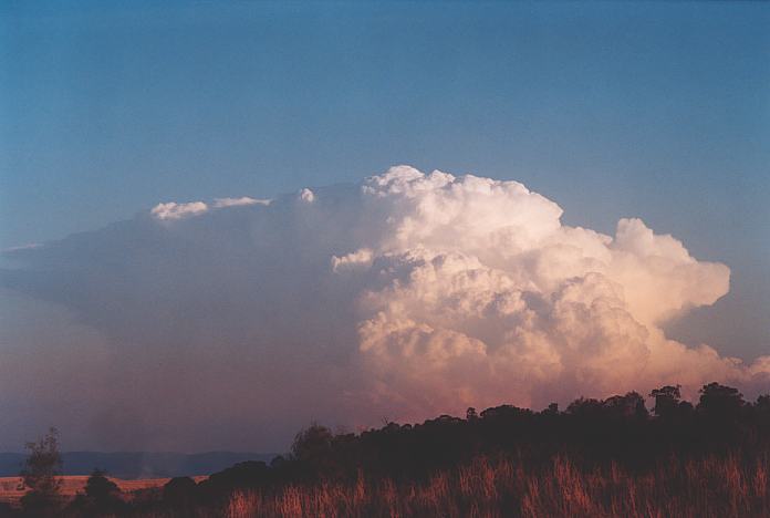
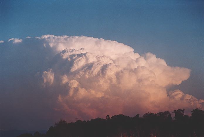
Whilst Matt Smith concentrated on the video, I shot stills of the everchanging beautiful structure. Its orientation meant that the anvil was hidden in the shadow. Finally, a corkscrew updraught eventuated within the structure. This to me confirmed there was some evidence of rotation and that the storm was indicating supercellular behaviour.
This was definitely an awesome sight. It was isolated with a hard crisp top. And now backshearing as the storm began to properly glaciate as well as develop and overshooting dome. We all watched as the sun slowly set illuminating a changing colour onto the cell. Everything seemed to be happening in slow motion.
After sunset, Geoff and I decided to head back down via the Putty Road to Sydney hoping for some sort of lightning show. We thought the cell was still going during the night whilst at Windsor but our bearings were wrong. It was a cell to the southeast rather than the east.
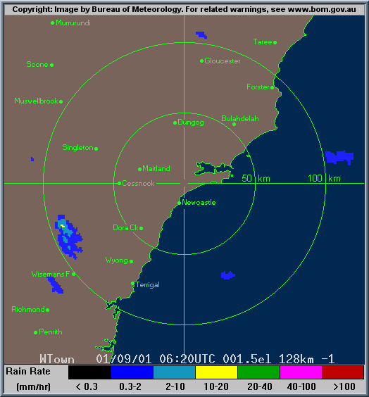
Reports of hail damage from Wyong nicknamed it the Wyong storm. Rob Webb from the Bureau confirmed it as a supercell and it showed some weak rotation on doppler and a hook echo or pendant on conventional radar.
Personally, I feel the storm was starting to get more organised before it collapsed. If this had lasted an hour or so longer over the conditions that existed over Wyong, I would not have been surprised if this had become tornadic. Thankfully, the picture of the wall cloud by Ben Whiteside in the affected region provided proof of the LP nature of the supercell. The fact that the storm deviated only 10 degrees from the mean level wind flow meant adds further weight to this argument. This is probably the reason that it did not show much reflectivity on radar earlier. Another component that we are not used to here on the east coast are that most supercells are on the HP (High Precipitation) part of the supercell spectrum. From observations, higher precipitation supercells tend to be more lightning active explaining why little static was observed from this LP supercell over Wyong.
If you (or someone you know) have any photographs or video of this storm or any other storm such as damage, the storm structure itself or hail, please feel free to contact Jimmy Deguara. Your contributions are very welcome. Please any photographs or video footage are important so don't discount anything.
From Bureau
of Meteorology.
Here is an account from Ben himself:
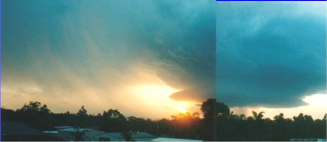
The photos were taken from a 2nd-story balcony looking due west. In the first photo (the panoramic shot) shows the rain band that had large amounts of hail. The cloud had a greeny tinge but did not come out too well on the photograph. The hail that did fall, fell for about 10 minutes and covered the ground like snow. Never before had I seen so much hail! Unlike other hailstorms that simply spread a few around the place, this one dumped it everywhere!
Behind the rain/hail shows the sun through the mist and then the main cell (probably the cloud structure in your photos on the web).
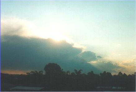
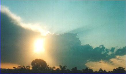
The other two photos were taken earlier on in the day.
The chase:
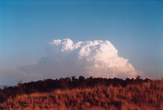
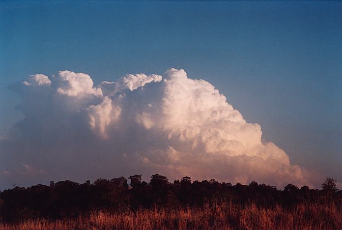
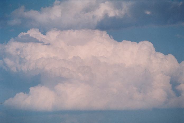 A large cumulus that had developed near Bulga could be observed slowly developing and moving east. It certainly showed signs of the wind shear evident with twisting in the updraught at the rear.
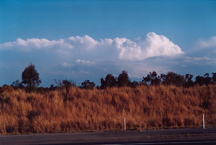 Matt indicated that there was occasional static on the radio. Some of these were indicating local strikes. It seemed that there was only large congestus over the ranges to the south and west over the Wollemi National Park. But then I began to take note of weak shallow spreading out of pretend glaciating anvils. It looked more like middle level cloud glaciating. Very shallow thundery activity to say the least but I believed it was responsible for at least some of the static.
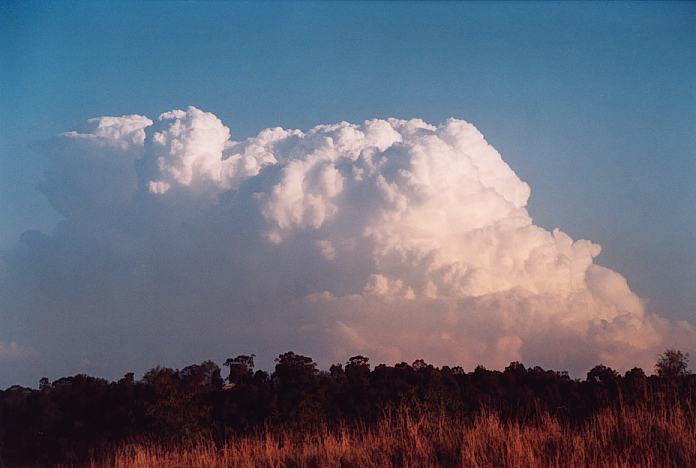
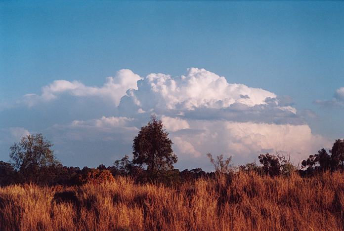 Illusive as it may have seemed, the weak thundery activity had snuck southeast. There was some encouragement as a rear section began to take off. This pulse had finally broken the cap. Each successive updraught brought fresh crisp moisture into the dry cold air aloft. This storm was slowly but surely shaping into a beautiful structure. The updraughts were shearing wherever it could but still more updraughts would fire up at the rear. We thought chasing it was waste of time as the speed would have it well off the coast by the time we had got near it.
 Phone calls and SMS messages came through steadily during this time as the storm showed evidence of becoming severe. In a phone call to Paul Graham, I hinted to him that there was a supercell structure but Paul showed more interest in storms to the south and near the Queensland and New South Wales border. He suggested there was not even lightning strikes on our storm. I could not believe it!!! Finally, he suggested there was one or two strikes.
 Whilst busy taking photographs and video, we noted a van stop near us. The driver Graeme Peterson was also watching and taking digital video of the storm. It was a pleasant surprise to see someone else take a keen interest of this storm. Graeme suggested that had been watching this cell for some time. He thought it was a fire from the distance. Well come to think of it, there was some smoke in the foreground.
Radar
Document: 200109-02.html
Updated: 24th April, 2002
[Australian Severe Weather index]
[Copyright Notice]
[Email Contacts]
[Search This Site]