and Chasing
[Index][Archives]
Severe Storms in Brisbane: Wednesday 28th January 1998
by Paul Miracki
| Storm News and Chasing [Index][Archives] |
Severe Storms in Brisbane: Wednesday 28th January 1998 by Paul Miracki |
The next day I saw a house that was nearly swept away. The fence to the backyard was completely wrecked and the whole backyard was filled with rubbish like grass and other things that came with the water, the house was allright because it was higher up. On the news they showed that some shops were flooded, and some classrooms in my school flooded because the rain was so heavy that it started to go through the roof.
Rainfall figures for the 24 hours to 9am 29/1/98
RAINFALL DARLING DOWNS AND GRANITE BELT: (13)

 ALLORA 11 BALLANDEAN 9 BARAKULA 45 BELL 39 BOWENVILLE 18 CAMBOOYA 3
 CECIL PLAINS 9 CHINCHILLA 41 CLIFTON 44 COOBY CREEK DAM 18
 COOLMUNDA DAM 92 DALBY 32 ELLANGOWAN 49 GLENELG 43 INGLEWOOD 59
 JANDOWAE 46 KARARA 23 LESLIE DAM 18 LEYBURN 45 MACALISTER 39
 MILES PO 2 MILLMERRAN 27 NOBBY 8 OAKEY 24 OAKINGTON 3 PITTSWORTH 13
 STANTHORPE 5 THE HEAD 3 TIPTON BRIDGE 29 TOOWOOMBA AWS 8
 UPPER PILTON 12 WALLANGARRA 9 WARAHGAI 29 WARWICK AWS 11 WAVERLEY 48
 WOMBALANO 35 YANGAN 4

 RAINFALL WIDE BAY AND BURNETT: (14)

 ABERCORN 58 BIGGENDEN 102 BRIAN PASTURES 65 BUILYAN 24 BUNDABERG 18
 CAMBOON 14 CANIA DAM 2 CERATODUS 25 COLODAN 3 DOUBLE IS PT 15
 DUNOLLIE 12 DURONG SOUTH 7 GAYNDAH 21 GIN GIN 36 GOOMBOORIAN 71
 GOOMERI 23 GYMPIE 91 HERVEY BAY 21 IMBIL 78 JIMNA 47 KANDANGA 70
 KILKIVAN 81 KINGAROY 18 MARYBOROUGH 80 MIVA 153 MONTO 39 MT BINGA 47
 MT MOWBULLAN 45 MUNDUBBERA 33 MURGON 18 NANANGO 29 PROSTON 22
 RAINBOW BEACH 28 ROSEDALE 25 SANDY CAPE 15 TOWN OF 1770 0.4
 WALLAVILLE 66 WOOLOOGA 101 YARRAMAN 53

 RAINFALL SOUTHEAST COAST: (15)

 AMBERLEY 8 BEAUDESERT 4 BEECHMONT 6 BOONAH 6 BROMFLEET 18
 CABOOLTURE 100 CANUNGRA 12 CANUNGRA ARMY 12 CAPE MORETON 27
 COOLANGATTA 5 COOROY 111 CROWS NEST 28 DARLINGTON 3 DAYBORO 38
 FOXLEY 4 GOLD CST SEAWAY 11 HINZE DAM 21 KENILWORTH 83 KILCOY 51
 LAKE COOROIBAH 68 LINDFIELD 44 LOGAN CITY 38 LOWOOD 27
 MACLEANS BRIDGE 23 MALENY 28 MAROOCHYDORE 91 MAROON DAM 3 MIAMI 24
 MOOGERAH DAM 4 MORAYFIELD 47 MT GLORIOUS 14 MT MEE 43 NAMBOUR 63
 NORWELL 29 PALMWOODS 55 PEACHESTER 51 PECHEY 28 PT ARKWRIGHT 84
 POINT LOOKOUT 27 POMONA 80 ROMANI 1 SOMERSET DAM 21 TAROME 7
 TEWANTIN AWS 65 WIVENHOE DAM 13 WOODFORD 53

 RAINFALL METROPOLITAN:

 ARCHERFIELD 80 BANYO 29 BRISBANE AP 31 BROWNS PLAINS 52 ENOGGERA 74
 GREENBANK 16 LONG POCKET 40 MANLY 25 MT GRAVATT 93 ORMISTON 35
 OXLEY 21 PA HOSPITAL 56 PETRIE 38 REDCLIFFE 4 SAMFORD 25
 STRATHPINE 76 SUNNYBANK 111 TOOMBUL 35 TOOWONG 56
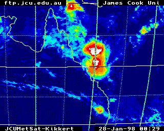
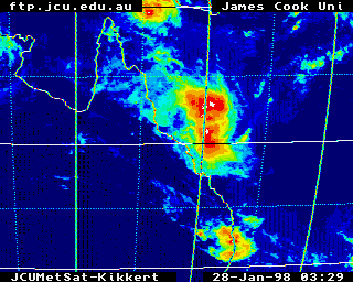
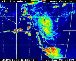
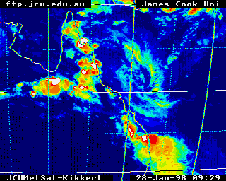
Synoptic Charts & Satellite Imagery
These images obtained from James Cook University
Infrared Satellite Image at 10am, 1pm, 4pm & 7pm Local Time
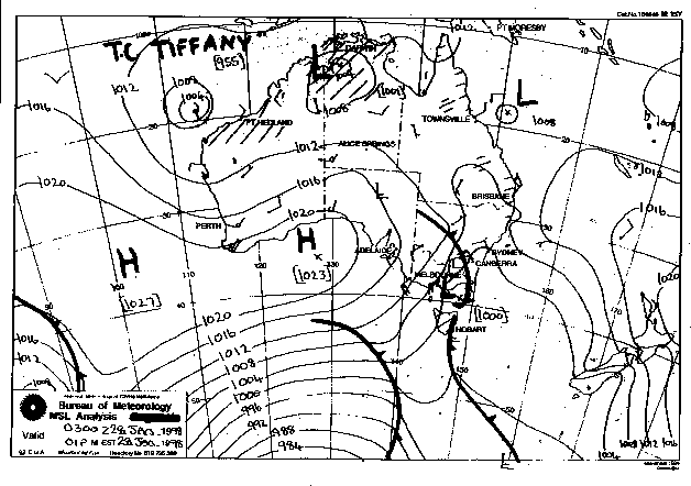
This image obtained from the Bureau of Meteorology
MSL Analysis 1 pm Local Time
|
Document: 9801-01.htm
Updated: 14th January, 2003 |
[Australian Severe Weather index] [Copyright Notice] [Email Contacts] [Search This Site] |